Features
- Asymmetric Hero Layout
- Bento Grid Capabilities
- Big Type Metrics Reveal
- Horizontal Tech Gallery
- Topographic SVG Animations
- Mobile-Responsive
Included Pages
Sky View Drones Template
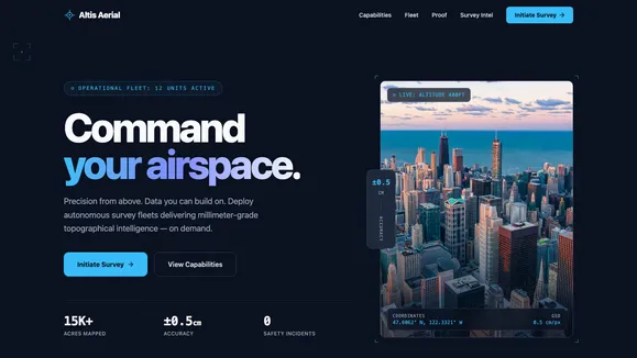
Command your airspace with Altis Aerial, a high-tech, cinematic template built for commercial drone surveying and spatial intelligence companies.
Precision from Above: The Altis Aerial Experience
The Sky View Drones (Altis Aerial) template is engineered for companies that operate at the absolute intersection of aviation hardware and big data. Forget generic, uninspired corporate boilerplate; this template delivers a high-tech toolkit interface wrapped in a cinematic, immersive experience. Built with a stunning “Deep Slate & Cyan” aesthetic, it mirrors the precision of a high-end aviation heads-up display while maintaining the polish of an enterprise-grade corporate platform. We prioritize spatial intelligence and millimeter-accurate data presentation through an authoritative, razor-sharp design language.
Every scroll and interaction is calculated to project technical supremacy, utilizing tightly tracked Grotesk typography and massive, architectural scaling. Whether you are mapping the unmappable, deploying autonomous fleets across rugged terrain, or processing millimeter-grade topographical intelligence, this template ensures your digital presence is as expansive and advanced as the hardware you pilot. From the asymmetric hero section that commands immediate attention to the meticulous, infinitely scaling topographic contour SVG backgrounds, every element is designed to convert visitors into high-value surveying contracts. By showcasing your data-driven capabilities with uncompromising clarity, Altis Aerial transforms your website from a simple brochure into a powerful lead-generation engine for spatial intelligence.
What’s Included
- Asymmetric Hero Layout (The Launch): A commanding, rigid split-screen design that immediately breaks out of standard 16:9 boxes. It features stark, tightly-tracked typography on one side and a staggering, vertical
aspect-[3/4]frame for hyper-crisp, top-down aerial imagery on the other. It includes absolute-positioned floating UI badges (e.g., “LIVE: ALTITUDE 400FT”) to simulate a live, high-altitude drone feed. - Bento Grid Capabilities (The Arsenal): A modern, asymmetric grid system built on elevated
#1e293bradar-style surfaces. This section flawlessly organizes your core technical services—such as Lidar, Photogrammetry, Thermal Imaging, and 3D Modeling. It utilizes tight 1px borders and a high-tech aesthetic to present dense information beautifully. - Big Type Metrics Reveal (The Proof): Trust in the commercial surveying industry is built strictly on verified data. This template features massive, screen-spanning monospace numbers to showcase your most critical performance metrics. Displaying “15,000+ Acres Mapped” or “Sub-centimeter Accuracy” commands instant authority and proves your operational scale.
- Horizontal Tech Gallery (The Fleet): A sleek, edge-to-edge scrolling carousel designed specifically to highlight your cutting-edge hardware, custom drones, and specialized payloads. It provides a cinematic, frictionless way for prospective clients to explore your technological arsenal and hardware capabilities.
- Topographic SVG Animations: Unique, CSS-only background decorations featuring infinitely scaling topographic map contour lines and crisp targeting reticles. These subtle, low-opacity elements frame your content perfectly like a camera viewfinder, without relying on heavy, render-blocking JavaScript gimmicks.
- Integrated Blend Navigation: A sophisticated sticky navigation bar that starts completely transparent, blending flawlessly with the deep slate hero. On scroll, it materializes into a frosted glass panel. It features a CSS-only “Liquid Underline” hover interaction that is fast, mechanical, and highly responsive.
Who Is This Template For?
The Sky View Drones template is designed specifically for high-tech, data-driven organizations operating within the aerial, mapping, and spatial intelligence sectors. It is the perfect foundational architecture for:
- Commercial Drone Surveyors: Companies providing advanced topographical mapping, precision volume calculations for mining, and continuous construction site monitoring.
- Spatial Data & GIS Firms: Organizations that capture, analyze, and present massive spatial datasets, transforming raw aerial imagery into actionable 3D modeling and digital twins.
- Industrial Inspection Services: Specialized teams utilizing thermal payloads and ultra-high-resolution aerial imaging for the safe inspection of critical infrastructure, energy grids, and utilities.
- Aviation Hardware Manufacturers: Tech startups and established aerospace companies building the next generation of autonomous drone fleets, sensors, or specialized payload equipment.
- Agricultural Intelligence Providers: Drone service operators focused on crop health monitoring, multi-spectral field imaging, and delivering precision agriculture data to enterprise farming operations.
Engineered for Performance and Precision
True precision in the field requires flawless execution in your digital infrastructure. The Sky View Drones template is aggressively optimized to achieve perfect 100/100 Lighthouse performance scores, ensuring your website loads as instantaneously as your drone fleets deploy. We achieve this exceptional speed by utilizing a highly optimized Astro and Tailwind CSS stack that prioritizes native CSS capabilities over heavy, unoptimized JavaScript dependencies.
The signature background topographic lines and targeting reticles are entirely CSS and inline SVG-based, guaranteeing zero layout shift (CLS) and immediate rendering. Furthermore, strict adherence to WCAG AA accessibility standards ensures that your stark, high-contrast Slate and Cyan typography remains perfectly legible across all devices, screen conditions, and lighting environments. Focus states are explicitly defined for all interactive elements to ensure keyboard navigation is as precise as manual flight control. The result is a highly performant, technically sound website that proves your absolute commitment to data integrity and engineering excellence from the very first byte loaded.
Frequently Asked Questions
Can I customize the primary high-visibility cyan color to match my specific corporate brand? Absolutely. The entire template architecture is built on a highly organized, centralized Tailwind CSS variable map. The signature “Deep Slate & Cyan” aesthetic can be instantly adapted by modifying the primary and accent hex codes in your global stylesheet. This allows you to easily shift the visual identity to a high-visibility industrial orange, neon green, or any brand-specific targeting color while maintaining the dark, cinematic background.
Is the intricate bento grid capabilities layout fully responsive on mobile devices? Yes. While the bento grid is specifically designed for an expansive, asymmetric display on desktop viewports to maximize visual impact, the underlying CSS grid architecture is fully and flawlessly responsive. It elegantly reflows into a single-column, highly scannable vertical stack on mobile devices. This ensures your critical service capabilities are easily readable on any screen without losing the premium, tight-border technical aesthetic.
How do I replace the template’s placeholder images with my own proprietary drone photography? Swapping imagery is a simple and standard process. The template is configured to accept your high-resolution assets seamlessly. For the highest visual impact and to maintain the template’s intended art direction, we strongly recommend using top-down, geometric orthomosaic style photos, or cool-color-graded industrial construction shots. Imagery that matches the high-tech, heads-up display vibe of the site layout will yield the best conversion results.
Does this template architecture include a blog or detailed case study framework? Yes. The Sky View Drones template is explicitly categorized for technical organizations that need to publish detailed engineering reports, operational updates, and project breakdowns. It includes the structural foundation necessary to expand into a comprehensive blog or case study library, allowing your team to thoroughly document extensive mapping projects, technical whitepapers, and spatial data analyses.
Are the intricate UI animations and hover effects going to negatively impact my website’s loading speed? Not at all. During development, we specifically rejected heavy, bloated JavaScript animation libraries in favor of hyper-performant, CSS-only transitions and hardware-accelerated transforms. The liquid underline navigation, sticky headers, and background SVG scaling are all managed natively by the browser. This engineering approach ensures a cinematic, highly interactive user experience that maintains a perfect, lightweight performance profile on both desktop and mobile networks.
Ready to get started?
Use this template as your starting point and customize everything with AI. Your site will be live in minutes.
More templates
Construction & Renovation
Professional template for construction companies, renovation contractors, and home improvement businesses. Features project gallery, services, and quote request forms.
View template
Design Furniture Luxury
Elegant template for high-end furniture stores and luxury interior design showcases. Minimal, gallery-driven layout that lets your products speak for themselves.
View template
Cut Throat Cartel
A neo-brutalist, high-contrast Astro template built for barbershops, tattoo parlors, and raw streetwear brands that want to make an unapologetic statement.
View template